Thank you very much for visiting Gunter's Space Page. I hope that this site is useful and informative for you.
If you appreciate the information provided on this site, please consider supporting my work by making a simple and secure donation via PayPal. Please help to run the website and keep everything free of charge. Thank you very much.
BKA 1, 2 (BelKa 2)
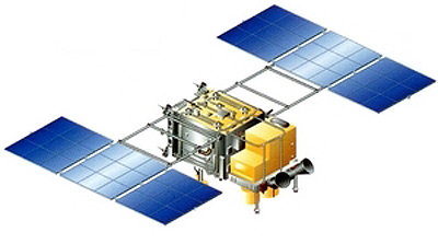
BKA (BelKa 2) [NPO VNIIEM]
BKA (formerly known as BelKa 2) is a Belarusian remote sensing satellite that replaces the BelKa 1 satellite lost in an launch failure.
The BKA satellite is a virtual copy of the Russian Kanopus-V 1. The resolution up to 2.1 m and four spectral channels of the target-oriented equipment allow for national economic tasks to the benefit of MINECONOMRESURS, Ministry of Natural Resources, Federal Geodesy and Cartography Service, EMERCOM, etc. In addition to key tasks the spacecraft will enable scientific and applied researches in the Earth and atmosphere remote sensing.
The satellite was built by NPO VNII Elektromekhaniki, who subcontracted the avionics suite to SSTL.
The tasks to be fulfilled by BKA are:
- Mapping (topographic and geodesic applications, government geodesic supervision);
- Cadastral account of estate property;
- Development of large building projects including gas and oil pipelines, railways, hydropower stations;
- Geological investigations and conservation of mineral resources;
- Environment monitoring including monitoring of forest fires and man-made emissions, glaciers and agricultural sector objects, etc.;
- Monitoring of forest condition;
- Monitoring of water bodies.
A similar second satellite, BKA 2, is planned for 2023 to replace BKA 1. It might be of a different design.
| Nation: | Belarus |
|---|---|
| Type / Application: | Earth Observation |
| Operator: | National Academy of Sciences of Republic of Belarus |
| Contractors: | NPP VNIIEM (prime); OAO Peleng (imager) |
| Equipment: | PSS, MSS |
| Configuration: | Kanopus bus |
| Propulsion: | 2 × SPT-50 |
| Power: | 2 deployable fixed solar arrays, batteries |
| Lifetime: | 5 years |
| Mass: | 473 kg |
| Orbit: | 505 km × 508 km, 97.49° |
| Satellite | COSPAR | Date | LS | Launch Vehicle | Remarks | |
|---|---|---|---|---|---|---|
| BKA 1 (ex BelKa 2) | 2012-039B | 22.07.2012 | Ba LC-31/6 | Soyuz-FG Fregat | with Kanopus-V 1, Zond-PP, exactView 1, TET 1 | |
| BKA 2 | - | 2025 | Vo LC-1S | Soyuz-2-1a | with ? |
References:
- SSTL: Kanopus (V1) & Kanopus (BKA)
- NPO VNIIEM: Белорусский космический комплекс