Thank you very much for visiting Gunter's Space Page. I hope that this site is useful and informative for you.
If you appreciate the information provided on this site, please consider supporting my work by making a simple and secure donation via PayPal. Please help to run the website and keep everything free of charge. Thank you very much.
Sentinel 3A, 3B, 3C, 3D
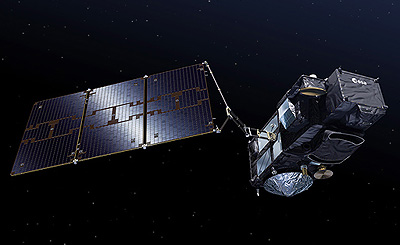
Sentinel 3 [ESA / Pierre Carril]
ESA and Thales Alenia Space signed in April 2008 a €305 million contract for the Sentinel-3 Earth Observation satellite on 14 April 2008. Sentinel-3 will be devoted to oceanography and land-vegetation monitoring, as part of the European GMES programme. As prime contractor, Thales Alenia Space is responsible for the satellite's design, development and integration.
Sentinel-3 will determine parameters such as sea surface topography, sea/land surface temperature, ocean colour and land colour with high-end accuracy and reliability. For this purpose, it carries an advanced radar altimeter and a multi-channel optical imaging instrument.
To achieve near-global coverage and meet all scientific requirements, Sentinel-3 will be placed in a high-inclination, sun-synchronous polar orbit. Near-realtime data processing and delivery will allow operational services to continuously profit from the mission.
ESA carried out the Sentinel-3 definition phase in 2005/6, drawing on an industrial consortium led by Thales Alenia Space. The implementation phase started in autumn 2007 and the launch of the first Sentinel-3 satellite is planned for 2012.
The satellite, designed for a minimum lifetime of 7 years, is carrying a payload comprising:
- Ocean and Land Color Instrument (OLCI), with strong heritage from MERIS instrument on Envisat, designed to monitor ocean conditions (currents, marine life etc.) and coastal zones (pollution, currents, etc.), to support more accurate predictions of changes in these conditions and better management of resources.
- The Sea and Land Surface Temperature Radiometer (SLSTR), with strong heritage from AATSR instrument on Envisat, will monitor the impact of climate changes on the temperature of our oceans as well as of the emerged land, and improve meteorological forecasts by fostering a better understanding of the relationship between oceans and the atmosphere.
- SAR Radar Altimeter (SRAL) with strong heritage from Cryosat and
- Microwave Radiometer (MWR), used to measure the topography of ocean surfaces, with quality equal to the data provided by the altimeters on Envisat. The mission will also cover the topography of ocean surfaces near coastal zones and ice masses. These measurements will allow us to better monitor the impact of climate changes (melting ice, rise in sea level, etc.), enhance maritime safety and improve meteorological accuracy by better understanding the relationship between oceans and the atmosphere.
- The precise orbit determination package including: a GNSS receiver, a laser tracking mirror and a Doris receiver
The OCLI and SLSTR instruments will also couple their data for a global vegetation monitoring mission, to determine the condition of vegetation and better manage its development. This mission was initiated by the Vegetation instrument developed by Thales Alenia Space in the 1990s.
Sentinel-3 features a 3 axis stabilized satellite flying in a frozen sun-synchronous orbit, with an orbit repeat cycle longer than 20 days as required for the topography mission and a local time at descending node located between 10:00 hr and 10:30 hr as desired for the optical instruments while keeping continuity with Envisat/ERS/SPOT missions. With a 1200 kg mass and 1.1 kW power consumption, Sentinel- 3 fits the baseline Vega launcher with Rokot-KM as back-up.
In December 2009 ESA signed a contract for a duplicate second spacecraft called Sentinel 3B. In January 2016, two more satellite, Sentinel 3C and Sentinel 3D, were ordered to be launched from 2021 onwards.
| Nation: | Europe |
|---|---|
| Type / Application: | Earth observation (Ocean) |
| Operator: | ESA |
| Contractors: | Thales Alenia Space |
| Equipment: | OLCI, SLSTR, SRAL, MWR, GNSS receiver, laser tracking mirror, Doris receiver |
| Configuration: | Prima Bus |
| Propulsion: | |
| Power: | Deployable solar array, batteries |
| Lifetime: | 7 years |
| Mass: | 1200 kg |
| Orbit: | 802 km × 806 km, 98.62° (#3A); 802 km × 815 km, 98.62° (#3B) |
| Satellite | COSPAR | Date | LS | Launch Vehicle | Remarks | |
|---|---|---|---|---|---|---|
| Sentinel 3A | 2016-011A | 16.02.2016 | Pl LC-133/3 | Rokot-KM | ||
| Sentinel 3B | 2018-039A | 25.04.2018 | Pl LC-133/3 | Rokot-KM | ||
| Sentinel 3C | - | 2024 | Ko ELV | Vega-C | ||
| Sentinel 3D | - | 2025 | Ko ELV | Vega-C (baselined) |
References:
- Thales Alenia Website