Thank you very much for visiting Gunter's Space Page. I hope that this site is useful and informative for you.
If you appreciate the information provided on this site, please consider supporting my work by making a simple and secure donation via PayPal. Please help to run the website and keep everything free of charge. Thank you very much.
ERTS 1 / Landsat 1, 2, 3

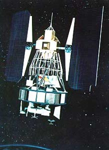
ERTS 1 (Landsat 1) [NASA]
Landsat 1 (formerly ERTS 1, Earth Resources Technological Satellite) was a modified version of the Nimbus 4 meteorological satellite. The near-polar orbiting spacecraft served as a stabilized, earth-oriented platform for obtaining information on agricultural and forestry resources, geology and mineral resources, hydrology and water resources, geography, cartography, environmental pollution, oceanography and marine resources, and meteorological phenomena. To accomplish these objectives, the spacecraft was equipped with:
- a three-camera return beam vidicon (RBV) to obtain visible and near IR photographic images of the earth,
- a four-channel multispectral scanner (MSS) to obtain radiometric images of the earth, and
- a data collection system (DCS) to collect information from remote, individually equipped ground stations and to relay the data to central acquisition stations.
ERTS 1, renamed Landsat 1 in 1975, carried two wide-band video tape recorders (WBVTR) capable of storing up to 30 min of scanner or camera data to give the spacecraft's sensors a near-global coverage capability. An advanced attitude control system consisting of horizon scanners, sun sensors, and a command antenna combined with a freon gas propulsion system permitted the spacecraft's orientation to be maintained within plus or minus 0.7 deg in all three axes. Spacecraft communications included a command subsystem operating at 154.2 and 2106.4 MHz and a PCM narrow-band telemetry subsystem, operating at 2287.5 and 137.86 MHz, for spacecraft housekeeping, attitude, and sensor performance data. Video data from the three-camera RBV system was transmitted in both real-time and tape-recorder modes at 2265.5 MHz, while information from the MSS was constrained to a 20 MHz rf bandwidth at 2229.5 MHz. The spacecraft was turned off on 6 January 1978, when cumulative precession of the orbital plane caused the spacecraft to see almost constant sunlight which led to overheating.
Landsat 2 and 3 were nearly identical satellites to extend the measurements.
| Nation: | USA |
|---|---|
| Type / Application: | Earth observation |
| Operator: | NASA |
| Contractors: | RCA Astro Space |
| Equipment: | RBV, MSS, DCS |
| Configuration: | Nimbus Bus |
| Propulsion: | ? |
| Power: | 2 deployable solar arrays, batteries |
| Lifetime: | 1 year design (#1 6 years, #2 7 years, #3 5 years reached) |
| Mass: | 816 kg (#1); 953 kg (#2); 960 kg (#3) |
| Orbit: | 897 km × 917 km, 99.1° (#1); 907 km × 918 km, 99.09° (#2); 897 km × 914 km, 99.1° |
| Satellite | COSPAR | Date | LS | Launch Vehicle | Remarks | |
|---|---|---|---|---|---|---|
| ERTS 1 → Landsat 1 (ERTS A) | 1972-058A | 23.07.1972 | Va SLC-2W | Delta-900 | ||
| Landsat 2 (ERTS B) | 1975-004A | 22.01.1975 | Va SLC-2W | Delta-2910 | ||
| Landsat 3 (ERTS C) | 1978-026A | 05.03.1978 | Va SLC-2W | Delta-2910 | with AMSAT P2D, PIX 1 |
