Thank you very much for visiting Gunter's Space Page. I hope that this site is useful and informative for you.
If you appreciate the information provided on this site, please consider supporting my work by making a simple and secure donation via PayPal. Please help to run the website and keep everything free of charge. Thank you very much.
Onyx 1, 2, 3, 4, 5 (Lacrosse 1, 2, 3, 4, 5)
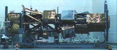
Onyx under construction [NRO]
The Onyx (formerly known as Lacrosse) satellites are terrestrial radar imaging reconnaissance satellite operated by the National Reconnaissance Office (NRO).
Martin Marietta (later Lockheed Martin) was the main contractor of these satellites. Onyx uses synthetic aperture radar (SAR) to perform mapping. Resolution is probably around 1 meter.
A space-based radar can penetrate clouds, and utilization of synthetic aperture radar (SAR) techniques can potentially provide images with a resolution that approaches that of photographic reconnaissance satellites. A project to develop a SAR satellite was initiated in late 1976 under project Indigo and later Lacrosse (the spelling Lacros was also used). Development of the Lacrosse system was approved in 1983. Before the first launch the program was renamed to Onyx. These satellites were launched under the designation Program 3100.
According to observers, the distinguishing features of the design of the Onyx satellite include a very large radar antenna, and solar panels to provide electrical power for the radar transmitter. Reportedly, the solar arrays have a wingspan of almost 45 meters, which suggests that the power available to the radar could be in the range of 10 to 20 kilowatts, as much as ten times greater than that of any previously flown space-based radar.
Onyx satellites are deployed in two different orbital inclinations, 57° and 68° of around 650 km height, but the satellites occasionally manoeuvre to different heights.
Based on leaked information, it appears, that there are two blocks with Onyx 1, 2 and 3 being Block 1 and the final two being Block 2. Based on ground based observations, the Block 1 spacecraft appear to have a large dish antenna, while Block 2 uses a rectangular planar antenna.
Onyx 1 was deorbited in 1997 and Onyx 2 on March 26, 2011.
The Onyx program ended after the 5th satellite. The follow-on program is Topaz (FIA-Radar).
Note: The NROL designations refer to the launch, not to the payload.
| Nation: | USA |
|---|---|
| Type / Application: | Reconnaissance, Radar (Data transmission type) |
| Operator: | NRO |
| Contractors: | Martin Marietta → Lockheed Martin |
| Equipment: | SAR |
| Configuration: | SA-Radar |
| Propulsion: | ? |
| Power: | 2 deployable solar arrays, batteries |
| Lifetime: | 9 years ? |
| Mass: | 14500 kg - 16000 kg ? |
| Orbit: | 437 km × 447 km, 57.0° (#1); 420 km × 662 km, 68.0° (#2); 666 km × 679 km, 57.0° (#3); 689 km × 695 km, 68.0° (#4); 718 km × 712 km, 57.0° (#5) |
| Satellite | COSPAR | Date | LS | Launch Vehicle | Remarks | |
|---|---|---|---|---|---|---|
| Onyx 1 (Mission 3101, USA 34) (ex Lacrosse 1) | 1988-106B | 02.12.1988 | CCK LC-39B | Shuttle | with Atlantis F3 (STS 27R) | |
| Onyx 2 (Mission 3102, USA 69) (ex Lacrosse 2) | 1991-017A | 08.03.1991 | Va SLC-4E | Titan-4(03)A | ||
| Onyx 3 (Mission 3103, USA 133, NROL 3) (ex Lacrosse 3) | 1997-064A | 24.10.1997 | Va SLC-4E | Titan-4(03)A | ||
| Onyx 4 (Mission 3104, USA 152, NROL 11) (ex Lacrosse 4) | 2000-047A | 17.08.2000 | Va SLC-4E | Titan-4(03)B | ||
| Onyx 5 (Mission 3105, USA 182, NROL 16) (ex Lacrosse 5) | 2005-016A | 30.04.2005 | CC SLC-40 | Titan-4(05)B |
References:
- Dwayne A. Day: Radar love: the tortured history of American space radar programs, in The Space Review
- Jeffrey T. Richelson: Ups and Downs of Space Radars, in Air Force Magazine