Thank you very much for visiting Gunter's Space Page. I hope that this site is useful and informative for you.
If you appreciate the information provided on this site, please consider supporting my work by making a simple and secure donation via PayPal. Please help to run the website and keep everything free of charge. Thank you very much.
GOES N, O, P, Q / EWS-G 1, 2
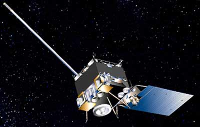
GOES N [Boeing BSS]
In January 1998, Boeing Satellite Systems, Inc.(BSS), of El Segundo, Calif., was awarded a contract from NASA's Goddard Space Flight Center in Greenbelt, Md. The contract includes the design, manufacture, integration and launch of two Geostationary Operational Environmental Satellites, GOES N and GOES O, with options for GOES P and GOES Q. The GOES program is funded and operated by the National Oceanic and Atmospheric Administration (NOAA).
Based on the highly successful BSS-601 spacecraft, the new satellites will provide more accurate location of severe storms and other weather phenomena, resulting in more precise warnings to the public. The three-axis BSS-601 body-stabilized spacecraft design enables the primary sensors to "stare" at Earth and thus frequently image clouds, monitor Earth's surface temperature, and sound Earth's atmosphere for its vertical temperature and water vapor distribution. Atmospheric phenomena can be tracked, ensuring real-time coverage of short-lived dynamic events, such as severe local storms and tropical hurricanes and cyclones, two types of meteorological events that directly affect public safety, property, and ultimately, economic health and development.
Boeing will furnish the communications subsystem with a search and rescue capability to detect distress signals from ships and airplanes, and will also furnish space environmental monitoring instruments and operator training. Ground station upgrades will be provided by Boeing's teammate Integral Systems Inc. BSS will also integrate three government-furnished instruments: and imager and sounder built by ITT Industries, Inc., and a solar X-ray imager built by Lockheed Martin.
The imager is a multispectral five-channel instrument that produces visible and infrared images of Earth's surface, oceans, cloud cover and severe storm developments. The multispectral sounder provides vertical temperature and moisture profiles of the atmosphere, augmenting data from the imager. Sounder data are also used in computer models which produce mid- and long-range weather forecasts. A new solar X-ray imager will monitor the sun's X-rays for the early detection of solar flares. This early warning is important because these solar flares affect not only the safety of humans in high-altitude missions, such as the Space Shuttle, but also military and commercial satellite communications. The GOES satellites also carry space environment monitoring instruments, built by Panametrics Inc., which monitor X-rays, extreme ultraviolet and particle emissions including solar protons, alpha particles, and electrons. These space environment monitoring instruments also include a magnetometer, built by Science Applications International Corporation (SAIC), which samples the Earth's magnetosphere.
A data collection system on GOES receives and relays environmental data sensed by widely dispersed surface platforms such as river and rain gauges, seismometers, tide gauges, buoys, ships, and automatic weather stations. Platforms transmit sensor data to the satellite at regular or self-timed intervals, upon interrogation by the satellite, or in an emergency alarm mode whenever a sensor receives information exceeding a preset level.
GOES 13 retired in 2018 has been repurposed as the Electro-Optical Infrared Weather System Geostationary, or EWS-G1 for the military. NOAA will continue to operate EWS-G1 on behalf of the U.S. Space Force for its remaining life span. It was retired and removed from GEO in November 2023, although the transfer maneuvere appears to have been not successful..
GOES-15 was transferred in September 2023 becoming EWS-G2.
| Nation: | USA |
|---|---|
| Type / Application: | Meteorology |
| Operator: | NOAA |
| Contractors: | Boeing |
| Equipment: | imager, sounder, solar X-ray imager, S-band, L-band, UHF communication channels |
| Configuration: | BSS-601 |
| Propulsion: | ? |
| Power: | Deployable solar array, batteries |
| Lifetime: | 10 years |
| Mass: | 3133 kg (1800 kg BOL) |
| Orbit: | GEO |
| Satellite | COSPAR | Date | LS | Launch Vehicle | Remarks | |
|---|---|---|---|---|---|---|
| GOES 13 (GOES N) → DOD 1 → EWS-G 1 | 2006-018A | 24.05.2006 | CC SLC-37B | Delta-4M+(4,2) | ||
| GOES 14 (GOES O) | 2009-033A | 27.06.2009 | CC SLC-37B | Delta-4M+(4,2) | ||
| GOES 15 (GOES P) → EWS-G 2 | 2010-008A | 04.03.2010 | CC SLC-37B | Delta-4M+(4,2) | ||
| GOES Q | - | cancelled |
References:
- Boeing: GOES N-P
Further SMS / GOES missions:
|
Further EWS missions:
|