Thank you very much for visiting Gunter's Space Page. I hope that this site is useful and informative for you.
If you appreciate the information provided on this site, please consider supporting my work by making a simple and secure donation via PayPal. Please help to run the website and keep everything free of charge. Thank you very much.
GEOS A, B (Explorer 29, 36)
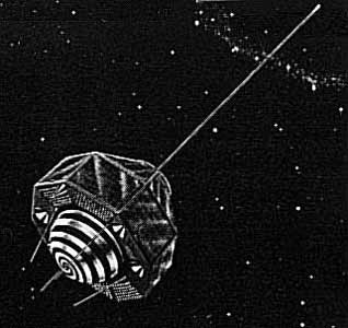
Explorer 29 (GEOS A) [NASA]
The GEOS 1 (Geodetic Earth Orbiting Satellite) spacecraft was a gravity-gradient-stabilized, solar-cell powered unit designed exclusively for geodetic studies. It was the first successful active spacecraft of the National Geodetic Satellite Program. Instrumentation included
- Optical Beacon System
- Laser Tracking Reflector
- Radio Doppler System
- SECOR Range Transponder
- Radio Range/Rate System
These were designed to operate simultaneously to fulfill the objectives of locating observation points (geodetic control stations) in a three dimensional earth center-of-mass coordinate system within 10 m of accuracy, of defining the structure of the earth's irregular gravitational field and refining the locations and magnitudes of the large gravity anomalies, and of comparing results of the various systems onboard the spacecraft to determine the most accurate and reliable system. Acquisition and recording of data were the responsibility of the GSFC Space Tracking and Data Acquisitions Network (STADAN). Ten major observing networks were used.
The GEOS 2 (Geodetic Earth Orbiting Satellite) was a gravity-gradient-stabilized, solar-cell-powered spacecraft that carried electronic and geodetic instrumentation. The geodetic instrumentation systems included
- Optical Beacon System
- Radio Doppler System
- SECOR Range Transponder
- Radio Range/Rate System
- C-Band Radar Transponder
- NASA Minitrack System
- Precipitating Electron Detector
- Magnetometer
- Laser Tracking Reflector
Non-geodetic systems included a laser detector and a Minitrack interferometer beacon. The objectives of the spacecraft were to optimize optical station visibility periods and to provide complementary data for inclination-dependent terms established by the Explorer 29 (GEOS 1) gravimetric studies. The spacecraft was placed into a retrograde orbit to accomplish these objectives. Operational problems occurred in the main power system, optical beacon flash system, and the spacecraft clock, and adjustments in scheduling resulted in nominal operations.
| Nation: | USA |
|---|---|
| Type / Application: | Research |
| Operator: | NASA |
| Contractors: | |
| Equipment: | Optical Beacon System, Radio Doppler System, Radio Range/Rate System, C-Band Radar Transponder, NASA Minitrack System, Precipitating Electron Detector, Magnetometer, Laser Tracking Reflector, TR-27 SECOR transponder (#A), TR-30A/S SECOR transponder (#B) |
| Configuration: | |
| Propulsion: | ? |
| Power: | Solar cells, batteries |
| Lifetime: | |
| Mass: | 387 kg (#A); 469 kg (#B) |
| Orbit: | 1113 km × 2275 km, 59.4° (#A); 1082 km × 1570 km, 105.8° (#B) |
| Satellite | COSPAR | Date | LS | Launch Vehicle | Remarks | |
|---|---|---|---|---|---|---|
| Explorer 29 (GEOS A) | 1965-089A | 06.11.1965 | CC LC-17B | Delta-E | ||
| Explorer 36 (GEOS B) | 1968-002A | 11.01.1968 | Va SLC-2E | Delta-E1 |
References:
- The Johns Hopkins University, Space Department: Artificial Earth Satellites Designed And Fabricated By The Johns Hopkins University Applied Physics Laboratory
- NSSDC Master Catalog: GEOS-A
- NSSDC Master Catalog: GEOS-B