Thank you very much for visiting Gunter's Space Page. I hope that this site is useful and informative for you.
If you appreciate the information provided on this site, please consider supporting my work by making a simple and secure donation via PayPal. Please help to run the website and keep everything free of charge. Thank you very much.
EnMAP
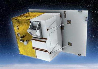
EnMAP [Kayser-Threde]
The German Aerospace Centre (DLR) and Kayser-Threde GmbH signed in June 2006 a contract for the development of the EnMAP satellite. EnMAP (Environmental Mapping and Analysis Programme) is a hyperspectral Earth observation satellite. Hyperspectral instruments will record solar radiation reflected from the Earth, from visible light to near infrared. This will provide accurate information about the condition of the Earth's surface and how it is changing. The mission, which is to be launched in 2012, is scheduled to last for five years.
The agreement assigns overall project management of EnMAP to DLR's Space Agency. DLR will also be responsible for building the ground infrastructure. Three bodies will be responsible for controlling the satellite, receiving, archiving and distributing data, and calibration: DLR's Space Operations Centre, the German Remote Sensing Data Centre (DFD) and the Remote Sensing Technology Institute (IMF) at Oberpfaffenhofen. DFD will also take on project management for the ground segment. In addition, DLR will be responsible for operating the satellite over the five-year mission. For its part, Kayser-Threde GmbH will handle development of the satellite while the GeoForschungsZentrum (GFZ) in Potsdam will manage the scientific aspects of the mission.
Conventional multispectral sensors record radiation reflected from the Earth in a small number of very broad channels. They provide reliable data and information, for example on land cover and its geographical distribution. These methods of measurement are adequate for qualitative research, for example regarding types of vegetation. But for quantitative information, for example relating to the supply of nutrients for crops or the quality of water in lakes, high-resolution spectral data is required.
The EnMAP satellite will be equipped with a ‘hyperspectral' sensor that will map the Earth's surface in over 200 narrow colour channels. This will give detailed information on waterways, vegetation, land usage and surface geology. The data will tell about the mineral composition of rocks, the level of damage to plant life caused by air pollutants, or the level of soil pollution, for example.
The satellite will be sent into an orbit approximately 650 km above the surface of the Earth. From this orbit, it will be able to overfly every point on Earth in four days. This makes EnMAP ideal for documenting changes over time and across different areas, such as processes of erosion or vegetation periods. Spectroscopic Earth observation can provide us with information about the distribution and status of ecosystems in many different natural environments, whether it be coastal areas, landscapes altered by human activity, steppes, deserts or forests.
The EnMAP mission is the first time that a high-quality hyperspectral sensor has been used in conjunction with a satellite. The data gathered by the satellite are expected to open up new possibilities for its use. This data may also help to answer current questions relating to the environment, agriculture, land usage, water management and geology using a single global standard. The data could be used by scientific institutions like the GeoForschungsZentrum in Potsdam for geological applications.
Orignially planned for a PSLV-CA launch in 2022, it was moved to a rideshare launch on a Falcon-9 v1.2 (Block 5) in eaerly 2022.
| Nation: | Germany |
|---|---|
| Type / Application: | Earth observation |
| Operator: | DLR, GFZ |
| Contractors: | Kayser-Threde (prime); OHB System (bus) |
| Equipment: | Hyperspectral camera |
| Configuration: | SmartLEO |
| Propulsion: | 2 × 1 N hydrazine thrusters |
| Power: | Solar cells, batteries |
| Lifetime: | 5 years |
| Mass: | 936 kg |
| Orbit: | 638 km × 651 km, 97.95° |
| Satellite | COSPAR | Date | LS | Launch Vehicle | Remarks | |
|---|---|---|---|---|---|---|
| EnMAP | 2022-033C | 01.04.2022 | CC SLC-40 | Falcon-9 v1.2 (Block 5) | with with EnMAP, ÑuSat 23, ..., 27, GNOMES 3, Hawk 4A, 4B, 4C, Lynk 05, ION-SCV 005, KSF 2A, ..., 2D, PlantSat, SUCHAI 2, SUCHAI 3, MP42, ARCSAT, Spark 1, Pixxel-TD 2, BRO 7, AlfaCrux, BDSAT, SpaceBEE 128, ..., 139 |